


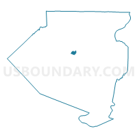
ROSS TWP WD 07 DIST 01, Allegheny County, Pennsylvania
About
Outline

Summary
| Unique Area Identifier | 656797 |
| Name | ROSS TWP WD 07 DIST 01 |
| County | Allegheny County |
| State | Pennsylvania |
| Area (square miles) | 0.88 |
| Land Area (square miles) | 0.88 |
| Water Area (square miles) | 0.00 |
| % of Land Area | 100.00 |
| % of Water Area | 0.00 |
| Latitude of the Internal Point | 40.50196690 |
| Longtitude of the Internal Point | -79.99857590 |
Maps

Graphs
Select a template below for downloading or customizing gragh for ROSS TWP WD 07 DIST 01, Allegheny County, Pennsylvania


Neighbors
Neighoring Voting District (by Name) Neighboring Voting District on the Map
- PITTSBURGH WD 26 DIST 14, Allegheny County, PA
- PITTSBURGH WD 26 DIST 15, Allegheny County, PA
- RESERVE TWP WD 03, Allegheny County, PA
- RESERVE TWP WD 04, Allegheny County, PA
- ROSS TWP WD 01 DIST 03, Allegheny County, PA
- ROSS TWP WD 07 DIST 02, Allegheny County, PA
- SHALER TWP WD 02 DIST 01, Allegheny County, PA
- SHALER TWP WD 02 DIST 03, Allegheny County, PA
Top 10 Neighboring County Subdivision (by Population) Neighboring County Subdivision on the Map
- Pittsburgh city, Allegheny County, PA (305,704)
- Ross township, Allegheny County, PA (31,105)
- Shaler township, Allegheny County, PA (28,757)
- Reserve township, Allegheny County, PA (3,333)
Top 10 Neighboring Place (by Population) Neighboring Place on the Map
Top 10 Neighboring Unified School District (by Population) Neighboring Unified School District on the Map
- Pittsburgh School District, PA (309,086)
- Shaler Area School District, PA (39,285)
- North Hills School District, PA (37,876)
Top 10 Neighboring State Legislative District Lower Chamber (by Population) Neighboring State Legislative District Lower Chamber on the Map
- State House District 30, PA (61,376)
- State House District 21, PA (57,711)
- State House District 20, PA (55,871)
Top 10 Neighboring State Legislative District Upper Chamber (by Population) Neighboring State Legislative District Upper Chamber on the Map
Top 10 Neighboring 111th Congressional District (by Population) Neighboring 111th Congressional District on the Map
Top 10 Neighboring Census Tract (by Population) Neighboring Census Tract on the Map
- Census Tract 4271, Allegheny County, PA (5,510)
- Census Tract 4272, Allegheny County, PA (4,899)
- Census Tract 4292.02, Allegheny County, PA (4,365)
- Census Tract 4291, Allegheny County, PA (2,510)
- Census Tract 4282, Allegheny County, PA (2,091)
- Census Tract 2612, Allegheny County, PA (1,051)